
Today’s Current Affairs: 20th March 2026 for UPSC IAS exams, State PSC exams, SSC CGL, State SSC, RRB, Railways, Banking Exam & IBPS, etc
Table of Contents
Methane : Data
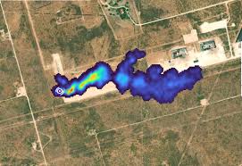
Satellite data processed by Carbon Mapper shows that 15 of the world’s top 25 methane emission sites in 2025 from the oil and gas sector were in Turkmenistan.
- Methane is a potent greenhouse gas, responsible for about 30% of the global temperature rise since the Industrial Revolution.
- Its atmospheric concentration is now 2.5 times higher than in the preindustrial era and is rising faster than other greenhouse gases.
- It is the primary component of natural gas and a byproduct of fossil fuel exploration.
- It is 86 times more efficient at trapping heat over a 20-year-period than carbon dioxide.
- The three major anthropogenic sources of methane emissions are agriculture, energy, and waste sectors
- It is a colourless, odourless, and highly flammable gas, also known as marsh gas.
- Although it remains in the atmosphere for a shorter period — about 12 years — than carbon dioxide,
- It traps far more heat in the near term, making it a key driver of short-term climate change, contributing 28 times more to global warming than carbon dioxide for every tonne.
Ethyl Chloroformate:
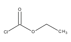
India has launched an anti-dumping investigation into imports of ethyl chloroformate from China after domestic producer alleged that the chemical was being sold in the Indian market at unfairly low prices.
- It is a colorless to yellowish liquid with a pungent odor.
- It hydrolyses in the presence of water.
- It is very toxic by inhalation and corrosive to metals and tissue.
- Its vapors are heavier than air.
- It is highly flammable and emits fumes containing HCl on contact with moist air.
- It decomposes exothermically.
- It is slightly soluble in water; soluble in organic solvents like ethanol and ether.
- It should be stored in a cool, dry, and well-ventilated area in tightly closed containers away from sources of ignition and incompatible materials.
- It was used in the synthesis of nitrile oxides.
- It is used as an intermediate in organic synthesis, particularly in the production of pharmaceuticals, agrochemicals, and other specialty chemicals.
- Health Impact: Prolonged exposure to low concentrations or short exposure to high concentrations may have adverse health effects from inhalation.
Legionnaire’s Disease:
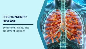
Legionnaires’ disease cases reported in London and New York has raised global alarm, with public health experts warning that densely populated cities, including those in India, could face similar risks if preventive measures are not strengthened.
- It is a severe form of a lung infection (pneumonia) caused by a bacterium known as legionella.
- The disease got its name when a group of people at an American Legion convention became ill with this type of pneumonia in 1976.
- Legionella is found naturally in freshwater, such as lakes and rivers. It can also be found in soil.
- Most people who catch Legionnaires’ disease breathe in the bacteria from water or soil.
- One can’t get infected by drinking water that contains the bacteria unless you aspirate it (accidentally breathe the water into your lungs).
- It is not contagious, meaning it is not spread from person to person.
- Older adults, people with weakened immune systems, and people who smoke have a higher risk of getting Legionnaires’ disease.
- It causes pneumonia-like symptoms that start two to 14 days after exposure to Legionella.
- Patients usually present with fever, cough, shortness of breath, tiredness, headache, muscle pain, and may have gastrointestinal symptoms such as abdominal pain and diarrhoea.
- In severe cases, neurological symptoms (e.g., confusion) and respiratory failure may occur, and some cases may result in death.
- It can be treated with antibiotics.
- But some people still have problems after treatment.
- Currently, there is no vaccine available for LD
Sathyamangalam Tiger Reserve:
The Tamil Nadu government has informed the Madras High Court that illegal resorts operating in the eco-sensitive zone of Sathyamangalam Tiger Reserve (STR) have been locked and sealed.
- Sathyamangalam Tiger Reserve is located in Tamil Nadu.
- It is nestled at the junction of the Eastern and the Western Ghats in the Nilgiri Biosphere Reserve
- It is contiguous with the Mudumalai Tiger Reserve, Bandipur Tiger Reserve (Karnataka), and BR Tiger Reserve and Wildlife Sanctuary (Karnataka).
- The terrain is hilly and undulating with altitude ranging between 750 m and 1649 m.
- It is subtropical and dry.
- The summers are hot and dry; the monsoons are wet and cooler, with river flooding.
- Some of the prominent rivers in the region include the Bhavani, Moyar, and Noyyal rivers.
- It is home to several indigenous tribal communities, including the Irula and Kurumba tribes.
- It consists of southern tropical dry thorn forests, mixed deciduous forests, semi-evergreen forests, and riparian forests.
- It includes teak, sandalwood, bamboo, Terminalia, and Albizia, alongside medicinal plants and shrubs that support both wildlife and local communities.
- The major species are Elephant, Tiger, Panther, Sloth bear, Gaur, Black Buck, Spotted deer, Wild boar, Black napped hare, Common langur Nilgiri langur, Striped neck mongoose, and Bonnet macaque.
Hypercapnic Hypoxia in Mangroves:
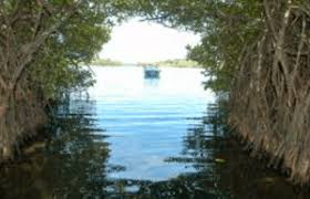
A new study revealed that most mangrove sites already experiencing mild or severe hypercapnic Hypoxia.
- Hypercapnic Hypoxia is a high CO₂ and low oxygen state.
- It pushes estuaries into a stressful chemical state.
- It mostly occurs during low tide, at low-salinity sites and in warm tropical regions.
- Causes: Rising Co2 level due to climate change and Temperature Increase
- It threatens fish nurseries in mangrove ecosystems
- It reduces biodiversity and habitat quality for fish
- It shifts mangrove species composition away from large reef-associated species.
- Mangroves are salt-tolerant trees and shrubs that grow in coastal intertidal zones, primarily in tropical and subtropical regions.
- These unique ecosystems thrive in saline or brackish waters, withstanding harsh environmental conditions such as tidal fluctuations, high salinity, and low oxygen levels in the soil.
- Mangrove forests act as a crucial buffer between land and sea, providing habitat for various marine and terrestrial species.
South Shetland Island:
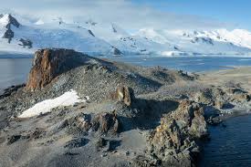
According to the German Research Centre for Geosciences (GFZ) a magnitude 6.7 earthquake struck the South Shetland Islands of Antarctica.
- The South Shetland Islands are a remote archipelago located about 120 kilometers (75 miles) north of the Antarctic Peninsula.
- The South Shetland Islands are often called the jewel in Antarctica’s crown.
- It was first discovered in 1819 by British mariner William Smith
- The islands were formed by volcanic activity, and some of the islands are still active today.
- The most well-known is Deception Island, which has a large, flooded caldera.
- More than 80% of the land area is covered by permanent ice.
- There are no permanent residents on this island. Some countries maintain small teams at research stations, depending on the season.
World Happiness report 2026:

According to a U.N.-backed World Happiness report 2026, heavy social media use is harming young people’s well-being in many countries.
- Top 5 Happiest Countries: Finland, Iceland, Denmark, Costa Rica, Sweden.
- Unhappy Countries: Afghanistan, Sierra Leone, Malawi, Zimbabwe
- India improved its ranking from 126th in 2024 to 118th in 2025.
- World Happiness Report is the world’s foremost publication on global wellbeing and how to improve it.
- It is an annual report published by the University of Oxford’s Wellbeing Research Centre in partnership with Gallup, the UN Sustainable Development Solutions Network
- It asks people to rate their life on a 0-10 scale, from the worst possible life (0) to the best possible life (10).
- Country rankings were based on answers given by around 100,000 people in 140 countries and territories who were asked to rate their own lives.
- Factors for evaluation of happiness ranking
- GDP per capita
- Life expectancy
- Social support
- Freedom to make life choices
- Generosity
- Perceptions of corruption
Floating LiDAR Buoy System:
The National Institute of Ocean Technology (NIOT) has successfully tested an indigenous Floating LiDAR Buoy System off the Muttom coast in Tamil Nadu.The Floating LiDAR (Light Detection and Ranging) Buoy is a sophisticated oceanic platform designed to provide high-resolution vertical wind profiles and meteorological data from the sea surface.Developed By the National Institute of Ocean Technology (NIOT), an autonomous body under the Ministry of Earth Sciences, Government of India.Aim is to accurately map offshore wind energy potential, enhance cyclone tracking, and provide real-time data for Blue Economy initiatives.
The system operates on the principle of Optical Remote Sensing.
- The buoy remains stable on the ocean surface while its integrated LiDAR unit emits infrared laser pulses into the atmosphere.
- These pulses hit aerosols, dust, and water droplets in the air and reflect back (Backscattering).
- The system measures the Doppler Shift in the frequency of the returned light to calculate wind speed and direction at various altitudes simultaneously.


