
Car Nicobar Island:
The Chief of Defence Staff recently inaugurated a major runway upgrade at the Indian Air Force’s Car Nicobar air base.
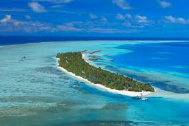
- It is part of the Nicobar district in the Andaman and Nicobar Islands Union Territory.
- It is the northernmost island of the Nicobar group.
- It lies south of Little Andaman and north of Nancowry Island.
- The ten-degree channel lies on the northern side of the island and separates the Andaman Islands and Nicobar Islands.
- Despite being a small island – under 127 sq.km. – it holds nearly half of Nicobar’s population (over 17,800 in 2011) and serves as the district headquarters.
- It is remarkably flat except for some cliffs in the north and small hilly areas in the interior.
- It is bordered by a silvery beach and areas of flat ground consisting of coraline diluvium.
- It is inhabited primarily by the Nicobarese tribal community (Scheduled Tribe).
- The climate of Car Nicobar Island is a tropical monsoon climate, as it is just 9 degrees from the equator, with an annual rainfall of 400 mm.
- The Car Nicobar islands do not have any evergreen forests, which dominate the central and southern islands of the Nicobars.
- Most of the island is covered with coconut plantations, and natural flora is present only in the interior areas.
- The island has been designated an Important Bird Area (IBA) by BirdLife International.
- The island was severely affected by the tsunami that was caused by the 2004 Indian Ocean earthquake, which led to many deaths and damaged infrastructure.
- Car Nicobar lies 750 km (470 mi) from the epicenter of the 2004 Indian Ocean earthquake, and the ensuing tsunamis struck it with great force.


