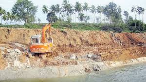
Sharavathi River : Illegal Sand Mining

The National Green Tribunal (NGT) recently directed the State Environment Impact Assessment Authority (SEIAA) and mines and geology department to stop any unlawful/illegal sand mining in Sharavathi river coastal zone.
- Sharavathi River is a river in westernKarnataka state.
- It is one of the few westward-flowing rivers in India and a major part of the river basin lies in the Western Ghats.
- Rising in the Western Ghats, it flows in a northwesterly direction to the Arabian Seaat Honavar in Uttara Kannada District
- The length of the river is 128 km, and the river basin covers 2,985 sq km.
- On its way, the Sharavathi forms the Jog Falls, one of the highest waterfalls in India, where the river falls from a height of 253 m.
- Major Tributaries: Nandihole, Haridravathi, Mavinahole, Hilkunji, Yennehole, Hurlihole, and Nagodihole.
- It is a vital source of hydroelectric power in Karnataka. Currently, the river generates a significant portion (40 percent or 1,469.2 megawatts) of the state’s hydropower using seven existing dams and five tunnels.


