Cyclone Remal:

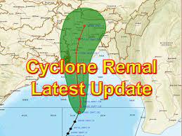
A new low-pressure area has been found over the southwest and adjacent west central Bay of Bengal as of May 22, 2024, early in the morning.
- This storm will move northeast and is likely to turn into a depression by May 24.
- The storm is likely to get stronger as it stays on the same path.
- By the evening of May 25, it will be in the northeast and adjacent northwest Bay of Bengal.
- Based on predictions on the US Global Forecasting System (GFS) that Cyclone Remal could form in the northwest Bay of Bengal by the morning of May 26.
- Additionally, The Weather Channel (TWC) has admitted that a cyclonic storm is likely to happen, even though it says the chances of it becoming a severe cyclonic storm are low.
- IMD says that some districts in West Bengal and Odisha will get light to moderate rain, and other districts will get heavy rain.
- In northeast India, places like Mizoram, Tripura, and south Manipur are expected to have similar weather.
- Also, from May 26–28, TWC predicts heavy rain—possibly more than 200 millimeters—in states like Assam, Meghalaya, Manipur, Mizoram, and Tripura.


