
Negros Island:
An earthquake measuring 5.8 in magnitude struck Negros Island, Philippines, recently.
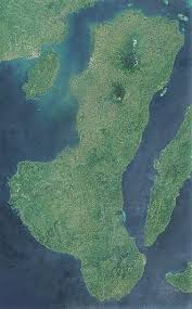
- Negros Island is one of the Visayan Islands, central Philippines.
- It is the fourth largest and third most populous island in the Philippines.
- It is a boot-shaped island that is 217 km long and 35 to 79 km wide.
- It is separated from the island of Panay to the northwest by the Guimaras Strait and from Cebu Island to the east by the Tanon Strait.
- The island is bordered on the north and south by the Visayan and Sulu seas, respectively.
- A central mountain range runs through the entire island and is deeply dissected by erosion.
- The range contains Mount Canlaon, an active volcano that at 8,086 feet (2,465 metres) is the highest point in Negros.
- This island has a rugged mountain interior, underwater coral gardens, and beautiful beaches.
- The island’s major rivers are the Binalbagan, Ilog, Tolong, and Tanjay.
- It is famed for its rich marine biodiversity and as the nation’s “Sugar Capital.”


