
Today’s Current Affairs: 30th Sep 2026 for UPSC IAS exams, State PSC exams, SSC CGL, State SSC, RRB, Railways, Banking Exam & IBPS, etc
Table of Contents
UN Declaration on Sea-Level Rise:
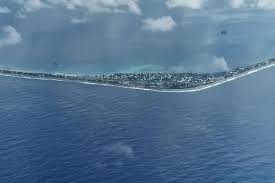
The United Nations General Assembly recently adopted its first declaration on sea level rise, with member states, including the US, agreeing on a common text.
- UN Declaration on Sea-Level Rise was adopted by the United Nations General Assembly during a high-level plenary meeting on September 24, 2026.
- It is the UN’s first declaration on sea level rise.
- The declaration establishes a common international position on the legal and practical challenges posed by rising seas.
- Global mean sea level reached a record high in 2024, and its rate of rise has doubled, from1 millimeters per year in 1993-2002 to 4.7 millimeters per year in 2015-2024.
Major Highlights of the Declaration:
- It affirms that countries threatened by rising oceans do not automatically lose their statehood if their territory becomes submerged.
- This means that the continued existence of a country under international law would not necessarily depend on its territory remaining above water.
- It supported the continued existence of such states’s sovereignty, rights, responsibilities, and UN membership.
- The issue is particularly relevant to small island developing States (SIDS), where rising seas can reduce habitable land and, in extreme cases, lead to the submergence of territory.
- It calls for stability in maritime zones despite physical changes to coastlines.
- It states that countries can maintain maritime zones established under the UN Convention on the Law of the Sea (UNCLOS) as sea levels rise, while retaining the right to update them.
- The issue arises because maritime zones are generally measured from coastal baselines.
- This is particularly important for island nations because maritime zones determine rights over ocean resources and activities.
- The declaration also addresses the wider threat that rising seas pose to coastal populations, infrastructure, and livelihoods.
- Without significant efforts to reduce emissions and adapt to rising seas, the risks facing coastal cities and communities could increase tenfold by 2100.
- The declaration calls for stronger anticipatory action, including multi-hazard early warning systems, and for climate-related risk assessments to be incorporated into planning and decision-making.
- It also urges greater international cooperation to provide financial, technical and policy support to developing countries, particularly SIDS and least developed countries.
- The declaration calls for increased funding to support local responses to sea level rise.
- It identifies nature-based measures, including the protection and restoration of mangroves, kelp forests, and seagrass meadows, as ways to help coastal communities adapt.
- The declaration also calls for sea level rise projections to be taken into account when planning, constructing, and maintaining critical coastal infrastructure.
Indian Peafowl : In News
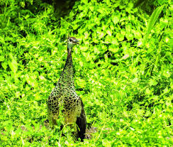
Orang National Park and Tiger Reserve recently recorded the Indian peafowl (Pavo cristatus) for the first time, adding a new species to the protected area’s biodiversity record and another chapter to Assam’s rich birdlife.
- Indian peafowl are a species in a group of birds called pheasants.
- The males are called peacocks, while the females are called peahens. Together, they are peafowl.
- Scientific Name: Pavo cristatus
- They are resident breeders across the Indian subcontinent and inhabit the drier lowland areas of Sri Lanka.
- They are found in moist and dry deciduous forests near water and in montane forests and can also adapt to live in cultivated regions and around human habitations.
- It is the national bird of India and has a significant cultural and historical presence.
- Peafowl are among the largest of all birds that fly.
- Males and females show strong physical differences.
- Peacock is brightly colored, with a predominantly blue fan-like crest of spatula-tipped wire-like feathers, and is best known for the long train (tail) made up of elongated upper-tail covert feathers, which bear colorful eyespots.
- These stiff feathers are raised into a fan and quivered in a display during courtship.
- Despite the length and size of these covert feathers, peacocks are still capable of flight.
- Peahens lack the train and have a greenish lower neck and duller brown plumage.
- Diet: Omnivorous; feeds on seeds, grains, fruits, insects, reptiles, and other small animals.
- Conservation Status:
- IUCN Red List: Least Concern.
Dengue Early Warning System:

Kerala scientists recently developed a Dengue Early Warning System (DEWS) using machine learning, six years of case data, and weather variables to forecast district-level dengue trends and help health authorities act before outbreaks intensify.
- Dengue (break-bone fever) is a mosquito-borne viral infection caused by the dengue virus (DENV).
- While many dengue infections are asymptomatic or produce only mild illness, the virus can occasionally cause more severe cases and even death.
- The virus is most common in tropical and subtropical regions, including Central and South America, Africa, parts of Asia, and the Pacific Islands, mostly in urban and semi-urban areas.
- Dengue epidemics tend to have seasonal patterns, with transmission often peaking during and after rainy seasons.
- It is transmitted to humans through the bite of infected Aedes mosquitoes carrying one of four types of dengue virus (DENV).
- It isn’t contagious from person to person except when passed from a pregnant person to their child.
- A person can be infected with dengue multiple times in their life.
- There is no specific medicine to treat dengue. The focus is on treating pain
- It is generally treated with supportive care such as pain relievers, bed rest, and fluids.
Swell wave:

The Indian National Centre for Ocean Information Services (INCOIS) has issued a Red Alert across all coastal districts in Keralam, warning residents and authorities of dangerous sea conditions caused by potential Swell waves.
- Swell waves are long-wavelength ocean waves formed on the surface of the seas and travel away from their places of origin.
- These are composed of a series of surface gravity waves.
- Swell waves are also called Kallakkadal waves in India, which is a colloquial term used by Keralam fishermen.
- These waves organise themselves into groups of similar heights and periods, and then travel long distances without much change.
- They are usually created by windstorms or other weather systems.
- Windstorms and other powerful air current systems transfer energy from the air to water, making swell waves more powerful than locally generated waves.
- During such storms, huge energy transfer takes place from the air into the water, leading to the formation of very high waves. Such waves can travel thousands of kilometres from the storm centre until they strike shore.
- They occur not due to the local winds, but rather due to distant storms like hurricanes, or even long periods of fierce gale winds.
- Swells have a narrower range of frequencies and directions than locally generated wind waves.
- It is because swell waves have dispersed from their generation area, have dissipated and therefore lost an amount of randomness, taking on a more defined shape and direction.
- These waves can propagate in directions that differ from the direction of the wind, in contrast to a wind sea.
- Their wavelengths may rarely exceed more than 150 m. Swell wavelength, also, varies from event to event. Occasionally, swells which are longer than 700 m occur as a result of the most severe storms.
- It occurs without precursors or any kind of local wind activity and as a result.
- Early warning systems in India: Indian National Centre for Ocean Information Services (INCOIS) launched the Swell Surge Forecast System in 2020 which gives forewaring seven days in advance.
Tiangong Space Station: In News
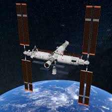
Pakistan is set to send its first astronaut into space under a cooperation programme with China, with one of two Pakistani candidates expected to join a short-duration mission aboard China’s Tiangong space station as a payload specialist.
- The Tiangong Space Station, translating to ‘Sky Palace’, is a Chinese-owned and operated permanently crewed space station in Low Earth Orbit (LEO).
- It represents the third and final step of China’s Manned Space Program.
- The first module of the space station was launched in 2021, following two precursor missions, Tiangong-1 and Tiangong-2.
- The station consists of a core module known as Tianhe, which connects two science modules, Wentian and Mengtian, as well as a planned space telescope module, Xuntian.
- Xuntian is a huge, Hubble-like space telescope, which will share the space station’s orbit and be able to dock with it for repairs, maintenance, and possibly upgrades.
- Tiangong orbits Earth at an altitude between 340 to 450 kilometers, approximately the same orbital height as the International Space Station (ISS).
- Tiangong is much smaller than the ISS, with only three modules compared with 16 modules on the ISS.
- Tiangong is also considerably lighter than the ISS, which weighs about 400 tons (450 metric tons); the Chinese station is about 20% as massive.
- But unlike the ISS, Tiangong is operated by a single nation.
- The station typically hosts three astronauts at a time for six-month stays. It can support six astronauts at a time during crew handovers.
- The aims of the Tiangong Space Station are to:
- Build a long-term, reliable space station in orbit.
- Guarantee the long-term health and safety of stationed astronauts.
- Provide conditions for scientific and technological experiments in space.
- The station serves as an in-orbit laboratory with enclosed experiment racks, each covering a different proposed experiment in the fields of:
- Space life sciences and biotechnology
- Microgravity fluid physics and combustion
- Material science in space
- Fundamental physics in microgravity
- The space station also features platforms for exposed and unpressurised external experiments.
National Digital Tourism Stack:

The Ministry of Tourism on World Tourism Day 2026 launched the National Digital Tourism Stack and the National Mission for Alternative Destinations -Dekho Apna Desh Campaign 2.0.
- National Digital Tourism Stack is an open digital public infrastructure initiative aimed at making tourism offerings more discoverable, accessible and trustworthy.
- It is being developed in collaboration with Open Network for Digital Commerce (ONDC) and the support of International Centre for DPI Innovation and Advancement (ICDIA).
- It will enable tourism providers to make their offerings available across participating platforms, supported by capabilities such as verified identities and supplier credentials, search and discovery, payments, ratings and grievance redressal.
- It is envisaged as a collaborative effort involving the Ministry, States, Union Territories and industry, the programme will be implemented in phases with a pilot planned for January 2027.
- National Mission for Alternative Destinations is a mission for distribution of tourism demand and promotion of lesser-known destinations under Dekho Apna Desh Campaign 2.0.
- It seeks to promote tourism-ready, lesser-known destinations across India to diversify domestic tourist flows, improve visitor experience and create opportunities for local communities and tourism enterprises.
- Four pillars of the Mission:
- Selection of destinations: States and Union Territories will nominate tourism-ready destinations with a distinct appeal, adequate infrastructure and accommodation capacity to receive additional visitors, and willingness to share tourism data.
- The pilot themes: Mountain alternatives, coastal and waterfront alternatives, heritage and cultural destinations, and regional pilgrimage alternatives.
- Packaging of tourism products: Selected destinations will be developed into bookable tourism products and themed itineraries integrating accommodation, transport, food, experiences and local activities.
- Joint promotion: Destinations will be promoted through coordinated campaigns with States, Union Territories and industry partners.
- Data-driven management: A national tourism monitoring dashboard or framework will support destination management by tracking tourist footfall, carrying capacity and visitor feedback.
- Selection of destinations: States and Union Territories will nominate tourism-ready destinations with a distinct appeal, adequate infrastructure and accommodation capacity to receive additional visitors, and willingness to share tourism data.
Ninth Edition Of The Exercise KAZIND:

A 60-member Indian Armed Forces contingent departed for Oskemen, Kazakhstan, to participate in the ninth edition of the Exercise KAZIND.
- Exercise KAZIND is a joint military exercise conducted between India–Kazakhstan.
- The Indian contingent is drawn mainly from a battalion of the GARHWAL RIFLES, along with troops from other arms and services, and personnel from the Indian Air Force.
- The exercise aims to enhance interoperability and strengthen the joint capability of both forces to undertake Joint Counter-Terrorism operations in a sub-conventional environment under a United Nations mandate.
- KAZIND-2026 will focus on:
- Joint Counter-Terrorism operations in semi-urban and mountainous terrain, with an emphasis on joint planning and execution, air mobility and the integrated employment of Unmanned Aerial Systems and Counter-UAS capabilities.
- The participating contingents will train together in joint responses to terrorist actions, raids, search-and-destroy missions, cordon-and-search operations, the securing of helipads and landing sites, and Special Heliborne Operations, among other activities.
- It will further deepen military-to-military cooperation between India and Kazakhstan and reinforce the shared commitment of both nations towards regional peace, stability and collective security.
Eurasian Whimbrel:
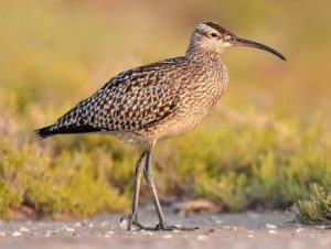
Eurasian whimbrel (Numenius phaeopus) was sighted at Kadalundi-Vallikkunnu Community Reserve of Keralam.
- Eurasian Whimbrel is a wading bird in the large family
- It winters mainly along the coastline, coastal wetlands, mangroves, marshes, and larger rivers.
- They have an extensive range that spans across five continents: North America, South America, Asia, Africa, and Europe.
- They breed in the subarctic regions of Siberia and Alaska during the summer months before migrating south to wintering grounds in southern USA, Central America, South America, Africa, and South Asia, including Nepal.
- It is generally solitary when nesting, the Whimbrel tends to become gregarious outside of the breeding season.
- Whimbrels are known for their high-pitched call consisting of a repetitive series of seven notes.
- Conservation Status:
- IUCN Red List: Least Concern
What is Kaladi?

The Union Minister of State in PMO recently stated that the “Kaladi”, the GI-tagged traditional dairy product of the Udhampur district of Jammu and Kashmir, has reached the commercial threshold for local and global consumption.
- Kaladi known as Kalari cheese or the “mozzarella of the Himalayas”, it is a traditional dairy product originated from the Ramnagar area, Udhampur district of Jammu & Kashmir.
- The local delicacy is traditionally made by Gujjar shepherds in the mountains of Kashmir.
- It is a traditionally ripened cheese made from cow’s or goat’s milk.
- Kalari was developed to preserve excess milk during the summer months, when the heat would make it difficult to store fresh milk.
- It received the Geographical Indication (GI) tag in 2023.
Dakhla Oasis:
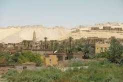
A rare pyramid-shaped tomb dating to the Roman period has been recently uncovered at Bir Al-Shaghala in Egypt’s Dakhla Oasis.
- Dakhla Oasis is a desert oasis located west of the Nile River, between Cairo and Luxor in Egypt.
- It is part of the Western Desert, which covers two-thirds of the land area of the country.
- It is known for its rich history and stunning landscapes.
- Nomadic hunter-gatherers first settled in Dakhla Oasis around 12,000 years ago.
- It has long been a crossroads between different parts of North Africa.
- Ancient routes passing through the region connected communities travelling between Egypt, the Sahara, and Libya, leaving behind evidence of repeated human activity.
- Among the most valuable remains are thousands of petroglyphs carved into exposed rock surfaces.
- Some depict animals that once lived in a wetter Sahara, while others show people, hunting scenes, and symbols connected to different periods of settlement.
- It was only connected to the outside world by a road built in the 80s, the so-called Great Desert Loop.
- The soil’s exceptional fertility makes Dakhla famous. Local farmers grow dates, olives, and other crops that are the foundations of the region’s agriculture.
- The oasis also features therapeutic hot springs like Bir Tarfawi and Bir Al-Gebel.
- Dakhla Oasis is home to several important sites, including Mut, Al-Qasr village, and the Dakhla Oasis Heritage Museum.
- An oasis is an area made fertile by a source of freshwater in an otherwise dry and arid region.
- Oases (more than one oasis) are irrigated by natural springs or other underground water sources.
- They vary in size from a cluster of date palms around a well or a spring to a city and its irrigated cropland.
- Dates, cotton, olives, figs, citrus fruits, wheat, and corn (maize) are common oasis crops.
- Underground water sources called aquifers supply most oases.
- In some cases, a natural spring brings the underground water to the surface. At other oases, manmade wells tap the aquifer.
Modhera Sun Temple:
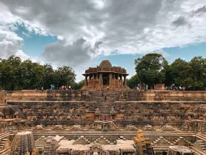
Prime Minister Narendra Modi recently highlighted the thousand-year history of Gujar Modhera Sun Temple, recalling its destruction during invasions and its subsequent reconstruction, while also highlighting the village’s transformation into India’s first 24×7 s village.
- Modhera Sun Temple is a Hindu temple dedicated to the solar deity Surya located at Modhera village of the Mehsana district, Gujarat.
- It is situated on the bank of the river Pushpavati.
- It was built after 1026-27 CE during the reign of King Bhima I of the Chaulukya dynasty.
- No worship is offered now and is a protected monument maintained by the Archaeological Survey of India (ASI).
- It entered the list of UNESCO World Heritage Sites in the year 2014.
- The temple complex is built in Maru-Gurjara style (Chaulukya style).
- The temple complex has three components: Gudhamandapa, the shrine hall; Sabhamandapa, the assembly hall; and Kunda, the reservoir.
- Each part is aligned along an east-west axis, reinforcing the temple’s connection to the sun’s movement.
- The halls have intricately carved exterior and pillars.
- Sabha Mandap standing on 52 pillars, depicting the 52 weeks in a year. The intricate carvings on the pillars depict scenes from ancient Indian epics Ramayana, Mahabharata and scenes from the life of Lord Krishna.
- The reservoir has steps to reach the bottom and numerous small shrines.
- On equinoxes, with the perfect planning and precision of the architecture, sun rays enter the main sanctum.
- In those days light was used to further reflect to other idols from the correctly placed diamond on the head of Sun God.
- The exterior walls are engraved with beautiful intricate carvings.