
GPS Aided GEO Augmented Navigation:
Under the watch of the Directorate General of Civil Aviation (DGCA) for the first time a private jet was landed by using GPS Aided GEO Augmented Navigation (GAGAN).
- GPS Aided GEO Augmented Navigation is a Satellite Based Augmentation System (SBAS) implemented jointly with Airports Authority of India (AAI) and ISRO.
- The main objectives of GAGAN are:
- To provide Satellite-based Navigation services with accuracy and integrity required for civil aviation applications.
- To provide better Air Traffic Management over Indian Airspace.
- It is interoperable with other international SBAS systems and provides seamless navigation across regional boundaries.
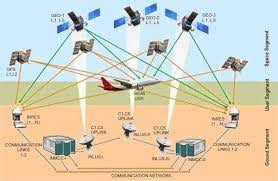
- It operates through a combination of ground-based and space-based segments to enhance the accuracy and reliability of the GPS signals.
- A network of 15 precisely surveyed ground reference stations (INdian Reference Stations) is strategically placed across India. These stations collect GPS satellite data.
- Through this, errors caused by ionospheric disturbances, satellite orbit errors and inaccurate clocks are corrected.
- The collected data is sent to the Indian Master Control Centre, where correction messages are generated to rectify any signal errors.
- The correction messages are then uplinked through the Indian Land Uplink Station.
- Through this, the corrected messages are sent to the geostationary satellites which then broadcast them to the aircraft.
- Space Segment includes the communication satellites which were flown as GSAT-8 in 2011, GSAT-10 in 2012 and GSAT-15 in 2015.
- These geostationary communication satellites carry the GAGAN payloads.
- The correction messages are broadcast through these satellites to GPS receivers on aircraft.


