
Odisha Coastal Erosion:
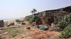
Union Minister for Ports, Shipping and Waterways informed the Rajya Sabha that 28.3% of Odisha’s 564-km coastline is undergoing erosion, based on a long-term assessment (1990–2022) by the National Centre for Coastal Research (NCCR).
- Coastal erosion is the progressive wearing away and landward displacement of beach or dune sediments caused by hydrodynamic forces such as waves, tidal currents, storm surges, and littoral drift.
- In Odisha, the interaction between severe tropical cyclones in the Bay of Bengal and human-made coastal structures alters natural sediment transport, resulting in rapid shoreline retreat, coastal flooding, and the loss of inhabited land.
Data & Statistics on Coastal Erosion in Odisha:
- Overall Coastline Dynamics: According to the NCCR mapping of Odisha’s 564.14 km coastline, 28.3% is eroding, 54.1% is accreting (growing), and 17.6% remains stable.
- Worst Affected Districts: Jagatsinghpur is the most vulnerable, with 47.6% of its 55.8-km coastline eroding, followed closely by Ganjam (45.7%) and Kendrapara (45.0%).
- Other Impacted Stretches: Moderate to low erosion is recorded across Balasore (23.8%), Puri (10.2%), and Bhadrak (4.6%).
- Submergence of Inhabited Land: Rising sea levels and coastal land loss have already submerged 16 entire villages in Kendrapara district alone, displacing hundreds of families.