
Tuti Island Sudan:
Tuti Island, historically known as a tranquil agricultural haven in Sudan, has become a focal point in the ongoing civil war between the Sudanese Armed Forces (SAF) and the paramilitary Rapid Support Forces (RSF).
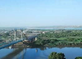
- Tuti Island is a crescent-shaped landmass of about 8 sq. km located at the confluence of the White Nile and Blue Nile in Khartoum, where the White Nile, flowing from Uganda, meets the Blue Nile from Ethiopia, and is one of the city’s oldest settlements.
- It is situated in the exact geographical center of Sudan’s tri-city metropolitan conurbation, bordered by Khartoum (the political capital) to the south, Omdurman (the largest city) to the west, and Khartoum North (Bahri, the industrial hub) to the northeast.
- Formed entirely by alluvial silt deposition from the Nile’s historical flooding cycles, making its soil exceptionally fertile.
- It has traditionally served as a key source of fresh produce for Khartoum, relying on farming and fishing, which earned it the nickname “Khartoum’s garden.”
- Inhabited primarily by the Mahas tribe since the late 15th century, the community has preserved traditional agricultural methods and indigenous early-warning flood management systems (known as the al-Taya system).
- After the April 2023 Sudan civil war began, the Rapid Support Forces (RSF) imposed a blockade (June 2023–March 2025), turning the island into an open-air prison with strict control over movement and supplies.
- Residents faced acute shortages of food, medicine, and fuel, often forced to pay heavy bribes to access essentials. The blockade reflects the use of starvation as a weapon.
- The HEART project (Heritage Empowered Action for Risk in Tuti) was launched to preserve the Taya system’s knowledge, which is threatened by displacement.


