
Today’s Current Affairs: 31st Oct 2026 for UPSC IAS exams, State PSC exams, SSC CGL, State SSC, RRB, Railways, Banking Exam & IBPS, etc
Table of Contents
Kariyachalli Island : In News
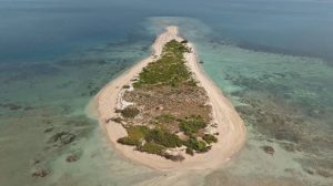
With two of the original 21 islands in the Gulf of Mannar already lost, Kariyachalli Island has become a test of whether engineering and ecological restoration can reverse an apparently relentless erosion trajectory.
- Kariyachalli Island is one of the 21 islands in the Gulf of Mannar Marine National Park region, located on the southeastern coast of India between Rameshwaram and Thhothukudi.
- The Gulf of Mannar is home to one of the four major coral reefs in India and is one of India’s most ecologically sensitive marine zones.
- The uninhabited island has sunk significantly over the past few decades due to rapid erosion, rising sea levels, and degradation of the surrounding coral reef and seagrass meadows.
- About a third of the coral around the island has bleached on average, and further degradation and disappearance of coral reefs would make the island more vulnerable to erosion, the report stated.
- The Tamil Nadu Government is undertaking restoration under the Tamil Nadu SHORE (Sustainably Harnessing Ocean Resources) project, with World Bank support.
Adi Tribe:
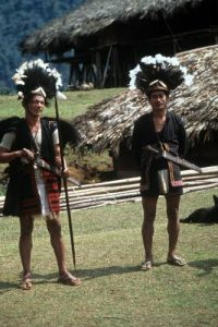
The proposed 11,200 MW Siang Upper Multipurpose Project has triggered fears that disruption to the river could destroy not only homes and farmland but also the roots of the Adi civilisation.
- The Adi tribe are one of the major indigenous tribal communities of Arunachal Pradesh.
- The name Adi means ‘hill man’.
- They primarily reside in the lower part of the Lower Dibang Valley district, particularly in Roing and Dambuk areas.
- They are believed to have come from southern China in the 16th century.
- The Adis have two main divisions (the Bogums and Bomis), and under each there are a number of sub-tribes.
- The Minyonfs, Karkos, Shimongs, Bomdo, Janbos, Panggis, Palibos, Bogums, Padams, Milangs, and so on form one group, while the Gallong and seven other groups constitute another group of Adis.
- Racially the Adi tribes belong to the Mongoloid stock with well-built features.
- The language spoken by Adis is called Adi, which is distantly related to the Chinese and Tibetan languages.
- It is spoken with minor variations among all the Adi tribes.
- The father is considered the head of the family.
- The Adis by nature are democratic and have a nicely organised village council, better known as “Kebang”.
- The Adi tribe is organized into several clans.
- This tribe is determinant of the social relationship and kinship.
- Family is the lowest unit of social organization and nuclear in character.
- Monogamy is the common form of marriage, though polygamy is socially restricted.
- Adi houses are constructed using wood and bamboo, featuring raised floors called “chang,” made from split bamboo over beams supported by wooden or bamboo stilts.
- Agriculture forms the backbone of Adi livelihoods, with both wet rice cultivation and shifting cultivation being practiced.
- In addition to agriculture, fishing and hunting play significant roles in supplementing food sources.
- Handicrafts of the Adi tribes are best seen in their cane and bamboo works like baskets, trays, haversacks, mats, and hats and headgears with artistic designs that are produced for domestic use.
- Women belonging to the Adi tribal group are expert weavers.
- The majority of Adi traditionally followed the animist Donyi-Polo religion, which involves the worship of the sun, the moon, and the ancestral god, the shaman, called Miri, can be a female.
- But, in modern times, many of the Adis have moved away from Donyi-Polo, especially the Adi youths, and have converted to Christianity.
- Their main festivals are Solung, Etor, and Aaran.
- Popular dances are the Ponung, Delong, Yakjong, and Tapu, which is in-fact, a war dance.
Dances performed are in-group lead by a main singer (Miri).
AIM-120 Advanced Medium-Range Air-to-Air Missile:

The US and Japan recently signed a deal to establish an AIM-120 Advanced Medium-Range Air-to-Air Missile (AMRAAM) facility in Japan, a move that will help bolster production of the most sought-after American beyond-visual-range air-to-air munition.
- AIM-120 Advanced Medium-Range Air-to-Air Missile (AMRAAM) is an active, radar-guided, medium-range, supersonic air-to-air missile.
- It is among the most widely used beyond-visual-range (BVR) air combat weapons in the world.
- Developed in the US in the late 1970s and 1980s, it became operational in 1991 with the US Air Force, replacing older radar-guided missiles.
- The AIM-120 is currently employed by over 35 countries, including key S. allies in NATO, the Asia-Pacific region, and the Middle East.
- Notable users include the United States, United Kingdom, Japan, Australia, and several NATO member countries.
- From American F-15s, F-16s, and F-35s to European aircraft like the Typhoon and Gripen, it is installed on a wide variety of fighter jets.
- The missile’s primary role is to achieve air superiority by engaging and destroying enemy fighters, bombers, and cruise missiles from beyond visual range.
- The missile features four cropped delta wings for lift and four control fins at the rear for steering.
- It is powered by a solid-fuel rocket motor capable of propelling it to speeds exceeding Mach 4.
- The missile can be launched in all weather, day or night.
- It has a range exceeding 160 kilometers under optimal launch conditions.
- It has a blast fragmentation warhead detonated by a proximity fuse.
- It utilizes a sophisticated guidance system that includes inertial guidance for the mid-course phase and terminal active radar homing for the final approach to the target.
- The missile also supports optional mid-course update data links, which enhance its accuracy by refining its trajectory during flight.
- This guidance system provides “fire-and-forget” capability, allowing the launching aircraft to disengage and focus on other threats.
AMRAAM-ER (Extended Range):
- It is a ground-launched variant with extended range and altitude
- It is intended for use in ground-based air defense systems like the NASAMS (National Advanced Surface-to-Air Missile System).
Kendriya Grihmantri Dakshata Padak 2026:
The ‘Kendriya Grihmantri Dakshata Padak’ has been awarded to 490 personnel for the year 2026.
- Kendriya Grihmantri Dakshata Padak has been instituted by the Ministry of Home Affairs, Government of India in 2024.
- The award aims to encourage professional standards and boost the morale of officers and officials across the country.
- It is given to recognize excellent work, promote high professional standards and boost the morale of the concerned official/officer in the following fields:
- Special Operation
- Investigation
- Intelligence
- Forensic Science
- It was created by merging the 4 previously existing MHA awards –The Special Operation Medal, Medal for Excellence in Investigation, Exceptional Intelligence Efficiency Medal, and Union Home Minister’s Award for Meritorious Service.
- It is conferred on members of the Police Forces, Security Organization, Intelligence Wing/Branch/Special Branch of State/Union Territories/Central Police Organizations (CPOs)/Central Armed Police Forces (CAPFs) and Forensic Science (Central / State / Union Territories) throughout the Indian Union.
- The medal is announced on 31st of October every year, on the occasion of the Birth Anniversary of Sardar Vallabhbhai Patel.
Bhimbandh Wildlife Sanctuary:

Bihar government has floated a tender for constructing sprawling tourism facilities inside Bhimbandh Wildlife Sanctuary despite statutory restrictions and a Supreme Court order restraining construction in protected areas.
- Bhimbandh Wildlife Sanctuary is located in Bihar.
- It is known for its natural hot springs.
- It predominantly has Northern Tropical Moist Deciduous Sal.
- It mainly consists of Shorea robusta (Sal), Terminalia tomentosa, Adina cordifolia, Syzygium cumini, aquatic macrophytes
- It is home to leopard, sloth bear, hyena, wolf, large Indian civet and barking deer.
Punah Bharan Mobile Application:
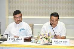
The Union Minister of Jal Shakti has launched the Punah Bharan Mobile Application..
- Punah Bharan Mobile Application is developed for advancing scientific groundwater recharge planning through geospatial technology.
- It is developed by the Bhaskaracharya National Institute for Space Applications and Geo-informatics (BISAG-N) in collaboration with the National Water Mission (NWM).
- It enables users to identify potential artificial recharge zones within a radial distance of up to 3 km and explore suitable recharge structures based on local conditions.
- It provides access to village-level Artificial Recharge Structure (ARS) zonation maps, GIS tools and thematic layers, supporting informed planning for sustainable groundwater management.
- The platform utilises geospatial datasets, including rainfall, groundwater levels, groundwater yield, slope and drainage, to help identify potential recharge areas and plan appropriate interventions.
Bhaskaracharya National Institute for Space Applications and Geo-informatics:
- It is an autonomous scientific society registered under the Societies Registration Act, 1860, under the Ministry of Electronics & Information Technology (MeitY), Government of India.
- Objective: To undertake technology development & management, research & development, facilitate national and international cooperation, capacity building, and support technology transfer & entrepreneurship development in the area of geospatial technology.
- BISAG-N has three main domain areas: satellite communication, geo-informatics and geo-spatial technology.
- BISAG-N provides specialized services and solutions in implementing map-based Geographic Information Systems (GIS).
- Location: Gandhinagar, Gujarat
National Social Security Board for Unorganised Workers and Gig & Platform Worker:
The Ministry of Labour and Employment has notified the constitution of National Social Security Boards for unorganised workers and gig and platform workers.
- National Social Security Board for Unorganised Workers and Gig & Platform Workers is established under the statutory framework of the Code on Social Security.
- The Boards are mandated to design, monitor, and recommend targeted welfare schemes to bridge the social security gap for millions of gig & platform workers alongside traditional unorganised workers.
- Composition:
- Chairman: The Boards will be presided over by the Union Minister for Labour & Employment.
- It comprise representatives from Central and State Governments, prominent aggregator companies, employers, civil society organizations, workers’ unions and gig & platform Associations.
- It shall meet at least thrice a year.
- Functions:
- It recommends to the Central Government for framing suitable schemes for different sections of unorganised workers, gig workers and platform workers;
- It advises the Central Government on such matters arising out of the administration of this Code as may be referred to it;
- It monitors such social welfare schemes for unorganised workers, gig workers and platform workers as are administered by the Central Government,
- It reviews the record keeping functions performed at the State level;
- It also reviews the expenditure from the fund and account; and
- It undertakes other functions as are assigned to it by the Central Government from time to time.
Tandur Red Gram : GI Tag

The first consignment of GI-tagged Tandur red gram from Telangana was flagged off from Hyderabad, Telangana, to Australia.
- Tandur Red Gram is popularly known as Tandur Toor Dal.
- It is primarily cultivated in the rainfed tracts of four mandals in the Tandur region namely Tandur, Basheerabad, Peddemul and Yelal of Telangana.
- Its distinctive characteristics are associated with the region’s fertile deep black soils, the presence of attapulgite clay mineral deposits, and substantial limestone deposits.
- It is the first agricultural product from the Telangana State to receive Geographical Indication (GI) registration in 2022.
- It has more protein content than cereals.
- It contains approximately 22–24 per cent protein, nearly three times the protein content of cereals.
- It is valued for its excellent taste, superior cooking quality, and enhanced storage quality.
Geographical Indications Tag:
- It is a sign used on products that have a specific geographical origin and possess qualities or a reputation that are due to that origin.
- This is typically used for agricultural products, foodstuffs, wine and spirit drinks, handicrafts and industrial products.
- The Geographical Indications of Goods (Registration and Protection) Act, 1999 seeks to provide for the registration and better protection of geographical indications relating to goods in India.
- This GI tag is valid for 10 years following which it can be renewed.
INS Srishti:

Goa Shipyard Limited (GSL) recently launched the next generation offshore patrol vessel (NGOPV) INS Srishti (Yard 1283) for the Indian Navy.
- INS Srishti is the fourth Next-Generation Offshore Patrol Vessel (NGOPV) built by Goa Shipyard Limited (GSL) for the Indian Navy.
- INS Srishti forms part of the Indian Navy’s NGOPV acquisition program.
- The project is being executed simultaneously by two Indian shipyards, with seven vessels being constructed by GSL and four by Garden Reach Shipbuilders & Engineers (GRSE).
- The program has been developed under the Buy (Indian-IDDM) category, placing emphasis on indigenous design, development, and manufacturing.
- Designed as versatile multi-mission platforms, the NGOPVs will undertake a broad range of operational tasks, including maritime surveillance, Search and Rescue (SAR), protection of offshore assets, Humanitarian Assistance and Disaster Relief (HADR), and anti-piracy
Key Features of NGOPVs:
- The NGOPVs are significantly larger and more capable than the Offshore Patrol Vessels.
- They can achieve speeds of up to 23 knots and have an endurance of 8,500 nautical miles at a cruising speed of 14 knots.
- The vessels can operate at sea for up to 60 days.
Sakurajima Volcano:
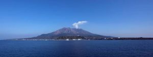
Japan’s Sakurajima volcano blasted a thick plume of ash into a clear blue sky recently.
- Sakurajima Volcano is located on the southern tip of Kyushu Island near the city of Kagoshima, Southern Japan.
- It lies in Kagoshima Bay (Kinkowan Bay), on the southern edge of the Aira Caldera.
- It is one of Japan’s most active volcanoes, and eruptions of varying levels take place on a regular basis.
- As it is situated on a convergent plate margin, Sakurajima is a stratovolcano formed from layers of lava and ash.
- It is an andesitic volcano.
- It consists of two principal volcanic peaks:
- Kitadake (Northern Peak): Older and currently inactive.
- Minamidake (Southern Peak): Younger and currently active.
What are Surangams?
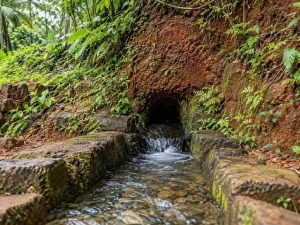
A comprehensive project to rejuvenate the district’s traditional underground water tunnels, known as “Surangams”, is set to be implemented in eight Gram Panchayats in Kasaragod District of Kerala.
- Surangams, also known as tunnel wells, are a remarkable indigenous water management system unique to the Kasaragod District of Kerala and parts of Dakshina Kannada in Karnataka.
- They are also known by different names, such as Surangas, Thurangams, or Thorappu.
- While its origins remain unclear, historians draw parallels to the Qanat system of Persia, introduced to India via the ancient Silk Route.
- These are basically horizontal tunnels dug through a laterite hillock through which water seeps out and into the tunnel.
- Water is then collected at the end of the tunnel in a storage pit.
- Built without pumps or electric motors, surangams rely entirely on natural water percolation.
- They channel underground water to the surface using gravity, ensuring a steady and sustainable supply for households and agriculture.
- Surangams are dug in places where the hydrogeological profile consists of lateritic and weathered rocks.
Dicharax tilariensis:
Researchers recently identified a new species of microscopic land snail named Dicharax tilariensis in Kolhapur’s Tilari region.Dicharax tilariensis is a new species of microscopic land snail.It was discovered in the Tilari region in the Kolhapur district of Maharashtra.The species inhabits the region’s semi-evergreen forests and is known to occupy microhabitats among forest litter, decaying organic matter, and moist soil.
United Nations political mission in Somalia ended after a two-year transition:
United Nations Assistance Mission in Somalia (UNSOM) was established by the UN Security Council in 2013.Purpose is to support Somali authorities in the transition to democracy and the rule of law after more than two decades of conflict involving militias, Islamist groups and criminal gangs.Its mandate ended on 31 October 2024, subsumed to the United Nations Transitional Assistance Mission in Somalia (UNTMIS).
Somalia:
- It is located in the Horn of Africa.
- The Equator passes through southern Somalia.
- Bordering Countries: It is bordered by Djibouti (Northwest), Ethiopia (West), and Kenya (Southwest).
- Maritime Borders: The Gulf of Aden and Indian Ocean
- Capital city: Mogadishu
- Rivers: It is drained by the Jubba and the Shabeelle rivers.
- Highest Peak: Highest point in Somalia is Mount Shimbiris (the 2,460 m tall).
- Natural Resources: It mainly consists of iron ore, uranium, copper, tin, bauxite, gypsum, salt.