
Assam-Mizoram Border Dispute:
Earlier in June this year, two abandoned houses along the Mizoram-Assam border were burned down by unidentified persons, fuelling tension along the volatile inter-state border.
- Now, early a month after this incident, the border dispute between the two neighbouring states has cropped up again, with both accusing each other of encroaching on their respective territories.
- According to the Mizoram side, people from Assam have violated the status quo – as agreed upon between the two State governments a few years ago – in “no man’s land” to trigger the present crisis.
- Mizoram was carved out of Assam as a Union Territory in 1972 and by 1987, it became a full-fledged state.
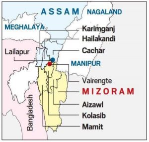
- The two states have sparred over this 164.6 km long inter-state border over the past, sometimes leading to violent clashes.
- The dispute stems from two notifications passed under British era:
- First, notification of 1875, that differentiated Lushai Hills from the plains of Cachar.
- Second, notification of 1933, that demarcates a boundary between Lushai Hills and Manipur.
- Mizoram claims that the land is theirs is based on an 1875 notification, which came from the Bengal Eastern Frontier Regulation Act of 1873.
- Assam for its part, claims that the land is theirs. It goes by a 1933 notification by the state government that demarcated the Lushai Hills, which Mizoram was formerly known as, from the province of Manipur.
- During colonial times, Mizoram was known as Lushai Hills, a district of Assam.
- The border between the two neighbouring states is an imaginary line that changes with the natural obstacles of rivers, hills, valleys and forests.
- People of Assam and Mizoram have attributed the border conflicts to the differences over this not-so-clear boundary.
- Hence, often people living in the border areas cross over to the other side as they are not fully aware of the border demarcation.


