
Deception Island : Picture By NASA
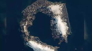
The National Aeronautics and Space Administration (NASA) recently posted a birds-eye-view picture of Deception island on its Instagram handle.
- Deception Island is part of a line of islands called the South Shetland Islands, lying northwest of the Antarctic Peninsula.
- It is an active volcano.
- It was formed by a massive volcanic eruption, which caused the central part of the volcano to collapse and allowed seawater to flood the center, or caldera.
- It has a unique landscape of barren volcanic slopes, steaming beaches, and ash-layered glaciers that form a distinctive horseshoe-shaped opening to the sea through a narrow channel at Neptune’s Bellows.
- The island surrounds Port Foster, one of the safest harbours in the Antarctic.
- It is one of the only places in the world where vessels can sail directly into the centre of a restless volcano.
- It’s one of two active volcanoes around Antarctica, and it has erupted more than twenty times since the 19th century.
- Three volcanic eruptions took place on the island between 1967 – 1970, destroying the Chilean and the British stations.
- At present, Argentina and Spain maintain summer scientific stations there.


