
LiDAR Survey : City By Amazon Rainforest Discovered
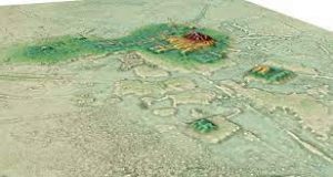
A huge city hidden by the luxuriant vegetation of the Amazon rainforest was recently discovered in Ecuador by a LiDAR survey.
- Lidar, which stands for Light Detection and Ranging, is a remote sensing method that uses light in the form of a pulsed laser to measure ranges (variable distances) to the Earth.
- These light pulses—combined with other data recorded by the airborne system — generate precise, three-dimensional information about the shape of the Earth and its surface characteristics.
- A lidar instrument principally consists of a laser, a scanner, and a specialized GPS receiver.
- Airplanes and helicopters are the most commonly used platforms for acquiring lidar data over broad areas.
- Lidar systems allow scientists and mapping professionals to examine both natural and man-made environments with accuracy, precision, and flexibility.
- It is used in a wide range of land management and planning efforts, including hazard assessment (including lava flows, landslides, tsunamis, and floods), forestry, agriculture, geologic mapping, and watershed and river surveys.


