
Today’s Current Affairs: 23rd July 2024 for UPSC IAS exams, State PSC exams, SSC CGL, State SSC, RRB, Railways, Banking Exam & IBPS, etc
Table of Contents
Brown Dwarfs : Study

Researchers have used James Webb Space Telescope observations to conduct detailed examinations of the atmospheric conditions on pairs of brown dwarfs.
- Brown dwarfs are celestial bodies bigger than a planet but smaller than a star
- These objects have a size between that of a giant planet like Jupiter and that of a small star.
- Brown dwarfs accumulate material like a star, not like a planet.
- They can also have clouds made out of precipitates in their atmospheres. However, while we have water clouds on Earth, the clouds on brown dwarfs are much hotter and likely made up of hot silicate particles.
- Thus, they hold onto their lighter elements (hydrogen and helium) more effectively than planets and have a relatively low metal content.
- However, brown dwarfs do not have enough mass for their cores to burn nuclear fuel and radiate starlight. This is why they are sometimes referred to as “failed stars.”
James Webb Space Telescope:
- It was launched in 2021 as a joint endeavour of the USA, European and Canadian space agencies.
- It is a large infrared telescope with an approximately 6.5 meter primary mirror.
- It does not orbit around the Earth like the Hubble Space Telescope; it orbits the Sun 5 million kilometers away from the Earth at what is called the second Lagrange point or L2.
Second Thomas Shoal:
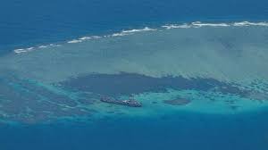
China and the Philippines have struck a deal to defuse tensions on a contested Second Thomas shoal in the South China Sea.
- Second Thomas shoal is a submerged reef (locally known as Ayungin) located in the Spratly Islands, South China Sea.
- The Philippines first took possession of the feature in The Philippine outpost on Second Thomas Shoal is the BRP Sierra Madre.
- The Second Thomas Shoal lies about 108 nautical miles (200 km) from the Philippine island of Palawan.
- China claims sovereignty over most of the South China Sea, including the Second Thomas Shoal, based on the historical and controversial Nine-dash line. China’s claims cut into the EEZs of Vietnam, the Philippines, Malaysia, Brunei and Indonesia.
Rogue Waves:
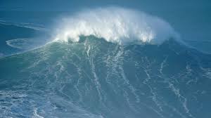
Researchers have developed a new tool that can be used to predict the emergence of unusually large and unpredictable waves at sea—known as rogue waves.
- Rogue waves are also known as Freak waves and are relatively rare, large and spontaneous ocean surface waves whose heights are larger than maximum wave height expected for a given sea state.
- These are formed from the coincidental stacking of multiple wind-driven wave crests passing through a single point or arising from a combination of waves
- Rogue waves tower to heights greater than twice the size of nearby waves, and they may move in either the same direction, the opposite direction, or at oblique angles to the prevailing wind and wave motion.
- They have been observed all over the world ocean and their characteristics are studied in the Mediterranean sea, the Pacific, the Atlantic, and some parts of the Indian Ocean.
- They are very unpredictable, and often come unexpectedly from directions other than prevailing wind and waves.
- The generation of freak waves is not only restricted to the open ocean, but also observed in the near-shore area, where these sudden waves cause damage to coastal structures and danger for small fishing boats.
- They look like “walls of water.” They are often steep-sided with unusually deep troughs.
National Centre For Polar And Ocean Research:
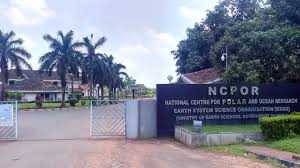
The National Centre for Polar and Ocean Research (NCPOR) is building a new ocean research vessel to explore the deep Indian Ocean for rare minerals and metals as part of India’s Deep Ocean Mission.
- National Centre for Polar and Ocean Research is an autonomous research instituteestablished in 1998.
- It is India’s premier R&D institution responsible for the country’s research activities in the Polar and Southern Ocean realms.
- It is tasked with planning and executing polar expeditions and scientific research in Antarctica, Arctic, Himalayas and the Southern Ocean.
- It is the nodal agency for planning, promoting, coordinating, and executing the entire gamut of polar and southern ocean scientific research in the country and the associated logistics activities.
- It also undertakes research on some of the country’s strategically vital projects like mapping of Exclusive Economic Zone (EEZ), continental shelf margins and the Deep Ocean Mission.
- The Center maintains a Research Advisory Committee (RAC) to help guide and concentrate the research activities.
- It is located in Vasco da Gama, Goa, and was formerly known as the National Center for Antarctic and Ocean Research (NCAOR).
- Nodal Ministry: Ministry of Earth Sciences (MoES), Government of India.
Upper Karnali Hydro-Electric Power Project:
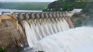
The Indian Renewable Energy Development Agency Limited (IREDA) is set to invest approximately ₹290 crore in the Upper Karnali Hydro-Electric Power Project.
- Upper Karnali Hydro-Electric Power Project is a 900 MW run-of-the-river hydropower project being developed on the Karnali River in Nepal.
- The project will supply power to Nepal, India, and Bangladesh for a contracted period of 25 years.
- The Government of Nepal awarded the project to GMR Upper Karnali Hydro Power Limited (GUKHL), a subsidiary of GMR Group India, under a memorandum of understanding (MoU) signed in January 2008.
- GMR is developing the project on a build-own-operate-transfer (BOOT) basis.
- The Nepal Government received 27% free equity in the project as part of the MoU with GMR.
- It is estimated to generate 3,466 million units of electricity, while offsetting approximately two million tons of greenhouse gas emissions a year.
- It will feature a concrete gravity dam, headrace tunnels, a fish pass, feeder tunnels, surge and pressure shafts, and silt flushing tunnels.
India Maritime Centre:
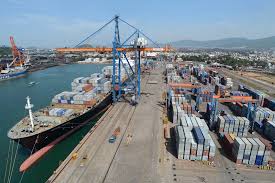
India Maritime Centre (IMC) moves closer to reality under the Maritime India Vision 2030.
- India Maritime Centre (IMC) is a cornerstone initiative of the Ministry of Ports, Shipping, and Waterways (MoPSW) under the Maritime India Vision 2030.
- It aims to provide a unified platform for the Indian maritime industry, acting as a think tank for policy formulation and industry recommendations.
- It is poised to be a pivotal institution in advancing India’s maritime interests both domestically and internationally.
- Its primary goals include Strengthening India’s participation in the International Maritime Organisation (IMO) and global maritime forums.
- Creating a robust domestic maritime sector through a unified and synchronised approach.
- Conducting flagship events to build a strong global brand for the Indian maritime cluster.
- Providing expert analysis and recommendations for sustainable growth.
- Establishing platforms for industry stakeholders to collaborate and network.
- Creating a pool of funds to support the industry, including startups.
- Mumbai has been finalized as the location for the IMC.
Uranium : Study
A new study by the Bhabha Atomic Research Centre (BARC) concludes that up to 60 µg/l of uranium in drinking water is safe, challenging the Bureau of Indian Standards’ (BIS) 2021 limit of 30 µg/l.
- The BIS standard aligns with WHO recommendations but the BARC study argues it may be counterproductive, adding unnecessary purification costs without health benefits.
- BARC researchers cite medical research indicating that small uranium concentrations do not pose health risks, including cancer.
- The study compares India’s standards to those of other countries, noting higher acceptable limits in nations with significant uranium consumption like Finland and Slovakia.
- The BARC study criticizes BIS for not conducting health impact studies before setting the 30 µg/l limit, unlike agencies such as the US Environmental Protection Agency.
- The study suggests retaining the Atomic Energy Regulatory Board’s limit of 60 µg/l, emphasizing the need for country-specific standards based on local conditions and economic factors.
Government Inaugurates National Landslide Forecasting Centre:
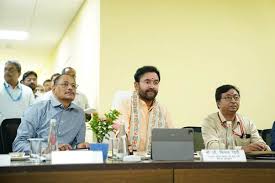
Union Minister G Kishan Reddy Inaugurates National Landslide Forecasting Centre and Launches Bhusanket Web Portal & Bhooskhalan Mobile App
- The National Landslide Forecasting Centre (NLFC) aims to mitigate landslide hazards in India. It provides early warning bulletins for landslide-prone states and plans to operationalize a nationwide Landslide Early Warning System (LEWS) by 2030
- Bhusanket Web Portal facilitates dissemination of information on landslide hazards and initiates short- and medium-range forecasting.
- Bhooskhalan Mobile App provides quick daily landslide forecasts.
- A landslide is “a movement of a mass of rock, earth or debris down a slope”.
Regional Consultation Program On The Science Of Natural Farming:

The “Regional Consultation Program on the Science of Natural Farming” emphasised the importance of natural farming as a sustainable agricultural practice.
- It was announced that farmers who practise natural farming on a portion of their land for 3 years will be eligible for government subsidies.
- Natural farming is an agricultural practice that emphasises minimal intervention and the use of natural resources to cultivate crops.
- It seeks to enhance soil health, biodiversity, and ecosystem balance without relying on synthetic fertilisers, pesticides, or herbicides.
- It is largely based on on-farm biomass recycling with major stress on biomass mulching, use of on-farm cow dung-urine formulations; maintaining soil aeration and exclusion of all synthetic chemical inputs.
- Several states, including Andhra Pradesh, Gujarat, Himachal Pradesh, Odisha, Madhya Pradesh, Rajasthan, Uttar Pradesh, and Tamil Nadu, have initiated programs to promote natural farming.
- Currently, over 10 lakh hectares of land in India are being used for natural farming.
National Flag Day 2024:
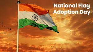
India’s National Flag Day commemorates the adoption of the Indian national flag on 22nd July 1947, by the Constituent Assembly, a few days before the country attained Independence from the British on 15th August 1947.
- On 22nd July 1947, the Constituent Assembly of India, chaired by Dr. Rajendra Prasad, adopted the National Flag.
- The National Flag symbolises national pride, unity, and the struggle for freedom, and is a tribute to the sacrifices of freedom fighters.
- Pandit Jawaharlal Nehru moved the Resolution, stating, “Resolved that the National Flag of India shall be horizontal tricolour of deep Saffron (Kesari), white and dark green in equal proportion.
- In the centre of the white band, there shall be a Wheel in navy blue to represent the Charkha.
- The design of the Wheel shall be that of the Wheel (Chakra) which appears on the abacus of the Sarnath Lion Capital of Asoka.
- The diameter of the Wheel shall approximate to the width of the white band.
- The ratio of the width to the length of the Flag shall ordinarily be 2:3.
- The assembly unanimously adopted the motion, marking the end of British rule and affirming India’s commitment to freedom and future prosperity.
Dyson Spheres : Study
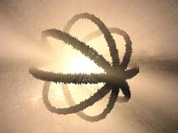
Dyson spheres are hypothetical megastructures built around a star to harness its entire energy output.
- Named after physicist Freeman Dyson, these structures would collect all of a star’s radiant energy.
- Detecting a Dyson sphere could indicate a technologically advanced alien civilization that prefers not to communicate.
- Earth receives 1,361 watts per square meter from the sun, a tiny fraction of the sun’s total energy output of 380 billion quadrillion watts per second.
- A Dyson sphere would capture all this energy that otherwise radiates into space.
- The Kardashev Scale is a theoretical framework to measure a civilization’s level of technological advancement based on its energy consumption.
- Humanity is currently at Kardashev Type 0.7449, not fully utilising the energy available on Earth.


