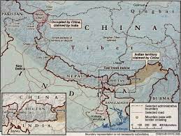
Line Of Actual Control (LAC) : Recent Updates

Indian and Chinese soldiers suffered “minor injuries” after they were engaged in a face-off along the Line of Actual Control (LAC) in Tawang sector of Arunachal Pradesh on December 9.
- India shares 3488 Km of border with China that runs along the States of Jammu & Kashmir, Himachal Pradesh, Uttarakhand, Sikkim and Arunachal Pradesh.
- The border is not fully and officially demarcated.
- The Line of Actual Control (LAC) is a demarcation line that separates Indian-controlled territory from Chinese-controlled territory.
- LAC is currently the de-facto border between the two countries, and the process of clarifying and confirming the Line of Actual Control (LAC) is in progress.
- The Line of Actual Control (LAC), is divided into three sectors: western, middle and eastern.
- Western (Ladakh, Kashmir),
- middle (Uttarakhand, Himachal) and
- eastern (Sikkim, Arunachal).
- As LAC is not fully and officially demarcated, it has led to differing perceptions regarding the alignment, with China making territorial claims in at following areas.
- The countries disagree on the exact location of the LAC in various areas, so much so that India claims that the LAC is 3,488 km long while the Chinese believe it to be around 2,000 km long.
- The two armies try and dominate by patrolling the areas up to their respective perceptions of the LAC, often bringing them into conflict.


