
Sir Creek Region:
The Defence Minister of India warned Pakistan against any aggression in the Sir Creek region, stating that India would give a “resounding and decisive response” that could alter “history and geography”.
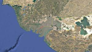
- Sir Creek is a 96 km long tidal estuary located in the marshy Rann of Kutch region, separating Gujarat (India) from Sindh (Pakistan).
- It flows into the Arabian Sea and is a strategically sensitive zone due to its proximity to the international boundary.
- The area is significant for security, fishing rights, oil and gas exploration, and Exclusive Economic Zone (EEZ) determination.
- The dispute arises from differing interpretations of the 1914 Bombay Government Resolution signed between Sindh (then under British India) and the Ruler of Kutch.
- Pakistan’s claim: The boundary lies on the eastern bank of the creek (giving the creek to Sindh).
- India’s claim: The boundary should follow the thalweg principle (mid-channel line of navigable waters).
- Pakistan’s counter-argument: Sir Creek is not navigable, hence the thalweg principle doesn’t apply.
- India’s stand: The creek is navigable during high tide, so international maritime norms apply.


