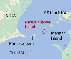
Katchatheevu Islands:

The Tamil Nadu Legislative Assembly has once again unanimously adopted a resolution urging the Union Government to retrieve Katchatheevu from Sri Lanka.
- Katchatheevu is a 285-acre uninhabited island situated in the Palk Strait between India and Sri Lanka.
- It is 33 km northeast of Rameswaram (India) and 62 km southwest of Jaffna (Sri Lanka).
- It Acts as a maritime boundary marker between India and Sri Lanka.
- Fisheries-rich zone, crucial for Tamil Nadu’s fishing economy.
- Anthony’s Church is a place of religious significance for fishermen of both nations.
- It was formed due to a volcanic eruption in the 14th century.
- Initially ruled by the Jaffna kingdom (Sri Lanka), later controlled by the Ramnad Zamindari under the Nayak dynasty (Madurai).
- British India and Sri Lanka both claimed the island until the 1974 agreement settled sovereignty in Sri Lanka’s favor.
- International Maritime Boundary Line (IMBL) between India and Sri Lanka was delineated in 1974 under the Indo-Sri Lankan maritime boundary agreement.
- Established based on UNCLOS (United Nations Convention on the Law of the Sea).
- Maritime boundaries are often defined by the equidistance principle, ensuring a medial line equidistant from both nations’ coasts.
- The IMBL determines Exclusive Economic Zones (EEZs), Territorial waters and other maritime zones.
- The 1974 agreement adjusted the equidistant line, leading to Katchatheevu falling under Sri Lanka’s sovereignty.


