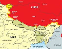
Line of Actual Control

The Union Ministry of External Affairs recently said that about 75% of the “disengagement problems” with China on the military standoff along the Line of Actual Control in eastern Ladakh have been “sorted out”
- Line of Actual Control (LAC) is the demarcation that separates Indian-controlled territory from Chinese-controlled territory.
- Although not recognised as an official border, it serves as a de facto border between India and China.
- India considers the LAC to be 3,488 km long, while the Chinese consider it to be only around 2,000 km.
- It is divided into three sectors:
- the eastern sector which spans Arunachal Pradesh and Sikkim
- the middle sector, in Uttarakhand and Himachal Pradesh, and
- the western sector in Ladakh.
- It runs along Tibet and Xinjiang on the Chinese side.
- The LAC has always remained a major cause of tension between India and China. There are areas along the border where India and China have differing perceptions of the LAC.
- Due to both sides undertaking patrolling upto their respective perceptions of the LAC, transgressions do occur.
- India’s claim line is the line seen in the official boundary marked on the maps as released by the Survey of India, including both Aksai Chin and Gilgit-Baltistan. This means LAC is not the claim line for India.
- In China’s case, LAC is the claim line except in the eastern sector, where it claims the entire Arunachal Pradesh as South Tibet.


