
Swarnamukhi River : Plan For Protection
The Tirupati Urban Development Authority (TUDA) recently announced Operation SWARNA, a massive plan to rescue the River Swarnamukhi from the clutches of land grabbers, revive its flow area and rejuvenate it to ensure sustenance.
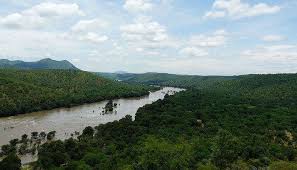
- Swarnamukhi River is a river in Andhra Pradesh.
- It is an east-flowing river basin having a small catchment area of 3,225 sq.km.
- It rises at an elevation of 300 m in the Eastern Ghat ranges near Pakala village in the Chittur district of Andhra Pradesh.
- It runs generally in the northeastern direction passing through the famous Tirupati hills before joining into the Bay of Bengal.
- Its total length is 130 km.
- It flows through the sacred regions of Tirumala and Srikalahasti, where notable Hindu temples like the Srikalahasteeswara Temple are located.
- Unlike larger river systems, the Swarnamukhi is independent, meaning it does not join or receive water from major river networks. Its flow is heavily dependent on rainfall, particularly in its upper catchment.
- The average annual rainfall in the Swarnamukhi basin decreases from 1270 mm at the eastern extremity of the basin to 762 mm at the western extremity.
- Its main tributary is the Kalyani River, across which the Kalyani Dam was constructed in 1977.


