
Zagros Mountains:
A geologist said that a hilly area surrounding the Zagros Mountains in Iraq is being pulled into Earth.
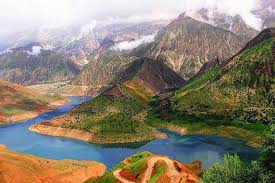
- Zagros Mountains is a major mountain range in West Asia.
- Scientists estimate that these Mountains were formed during orogenic episodes triggered by the sliding of the Arabian Plate underneath the Eurasian Plate during the Miocene and Pliocene Epochs.
- Historically, the Zagros Mountains have acted as a natural barrier between several cultures and empires of the ancient and modern worlds alike.
- It extends for a distance of 1,500 kilometers in a northwest to southeast direction from the border areas between eastern Turkey and northern Iraq across the Iranian Plateau, ending at the Strait of Hormuz in southern Iran.
- Mount Dena, with a peak achieving an elevation of 14,465 feet, is the highest peak in the Zagros Mountain system.
- The most commonly seen geological structural materials of the Zagros Mountains are Limestone and shale rocks from the Mesozoic Era and Paleogene Period.
- A semi-arid temperate climate prevails in the region, wherein the bitter winters are severely cold and experience deadly temperatures drop, while summers are highly arid.
- It consists of temperate broad-leaved forests, dominated by oak and pistachio trees, as well as dense ground covers of steppe vegetation.


