
Hindu Kush Himalaya : Lowest Snow
The Hindu Kush Himalaya (HKH) region recorded its lowest snow persistence in 23 years during the 2024–2025 winter, according to a new report published recently.
- The HKH mountains extend around 3,500 km over eight countries — Afghanistan, Bangladesh, Bhutan, China, India, Nepal, Myanmar, and Pakistan.
- It covers an area of approximately 4.2 million sq.km.
- It runs northeast to southwest and divides the valley of the Amu Darya (the ancient Oxus River) to the north from the Indus River valley to the south.
- To the east the Hindu Kush buttresses the Pamir range near the point where the borders of China, Pakistani-administered Kashmir, and Afghanistan meet, after which it runs southwest through Pakistan and into Afghanistan, finally merging into minor ranges in western Afghanistan.
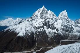
- The range has numerous high snow-capped peaks, with the highest point being Tirich Mir or Terichmir at 7,708 meters (25,289 ft) in Chitral, Pakistan.
- It is considered the Third Pole (after the North and South Poles) and has significant implications for climate.
- The HKH forms the largest area of permanent ice cover outside of the North and South Poles and is home to 4 global biodiversity hotspots.
- The HKH region is the source of ten large Asian river systems: the Amu Darya, Indus, Ganges, Brahmaputra, Irrawaddy, Salween, Mekong, Yangtse, Yellow River, and Tarim.
- The basins of these rivers provide water to 1.9 billion people, a fourth of the world’s population.
- Contains diverse ecosystems: glaciers, alpine meadows, forests, wetlands, and grasslands.
- HKH may be divided into three main sections: the eastern Hindu Kush, the central Hindu Kush, and the western Hindu Kush, also known as the Bābā Mountains.
- The inner valleys of the Hindu Kush see little rain and have desert vegetation.


