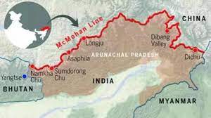
McMahon Line:

A recent bipartisan Senate resolution in the United States recognizes the McMahon Line as the international boundary between China and Arunachal Pradesh.
- McMahon Line is a geographical border between Northeast India and Tibet.
- It is the boundary between China and India, although its legal status is disputed by the Chinese
- It was negotiated between Tibet and Great Britain at the end of the Shimla Conference in 1914.
- It is named after Henry McMahon, who was the foreign secretary of British India and the chief negotiator of the convention at Simla.
- The length of this boundary is 890 kilometers.
- It runs from the eastern border of Bhutanalong the crest of the Himalayas until it reaches the great bend in the Brahmaputra River, where that river emerges from its Tibetan course into the Assam Valley.
- Though India considers the McMahon Line as the legal national border, China rejects it, contending that Tibet was not a sovereign state and therefore did not have the power to conclude treaties.


