
Assam-Meghalaya Border Dispute:
Assam and Meghalaya have partially resolved a 50-year-old border dispute in six of the 12 sectors along their 885-km boundary.
- Both states signed a “historic” agreement for a closure in six disputed sectors that were taken up for resolution in the first phase.
- The six disputed sectors are: Tarabari, Gizang, Hahim, Boklapara, Khanapara-Pillangkata and Ratacherra under the Kamrup, Kamrup (Metro) and Cachar districts of Assam and the West Khasi Hills, Ri-Bhoi and East Jaintia Hills districts of Meghalaya.
- Assam and Meghalaya share an 885-km-long border. Meghalaya was carved out of Assam under the Assam Reorganisation Act, 1971, a law that it challenged, leading to disputes.
- As of now, there are 12 points of dispute along their borders.
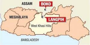
- These include the areas of Upper Tarabari, Gazang reserve forest, Hahim, Langpih, Borduar, Boklapara, Nongwah, Matamur, Khanapara-Pilangkata, Deshdemoreah Block I and Block II, Khanduli and Retacherra.
- A major point of contention between Assam and Meghalaya is the district of Langpih in West Garo Hills bordering the Kamrup district of Assam.
- Langpih was part of the Kamrup district during the British colonial period but post-Independence, it became part of the Garo Hills and Meghalaya.
- Assam considers it to be part of the Mikir Hills in Assam. Meghalaya has questioned Blocks I and II of the Mikir Hills -now Karbi Anglong region – being part of Assam. Meghalaya says these were parts of erstwhile United Khasi and Jaintia Hills districts.
- Both Assam and Meghalaya have constituted border dispute settlement committees.
- Recently, Assam Chief Minister Himanta Biswa Sarma and his Meghalaya counterpart Conrad Sangma decided to set up two regional committees to resolve the border disputes in a phased manner.
- Sarma recently said five aspects were to be considered in resolving the border dispute.
- They are historical facts, ethnicity, administrative convenience, mood and sentiments of the people concerned and the contiguity of the land.


