
Development Of Great Nicobar:
The Union Ministry of Environment, Forest and Climate Change gave environmental clearance for the ambitious Rs 72,000 crore development project on the strategically important Great Nicobar Island.
- The idea of developing Great Nicobar was first proposed in the 1970s, and its significance for national security and the consolidation of the Indian Ocean Region has been emphasised time and again.
- In recent years, increasing Chinese assertiveness in the Bay of Bengal and the Indo-Pacific has added urgency to this requirement.
About the Great Nicobar Island:
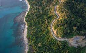
- Great Nicobar, the southernmost of the Andaman and Nicobar Islands, has an area of 910 sq km.
- The Andaman and Nicobar Islands are a cluster of about 836 islands in the eastern Bay of Bengal, the two groups of which are separated by the 150-km wide Ten Degree Channel.
- The Andaman Islands lie to the north of the channel, and the Nicobar Islands to the south.
- Indira Point on the southern tip of Great Nicobar Island is India’s southernmost point, less than 150 km from the northernmost island of the Indonesian archipelago.
- It covers 1,03,870 hectares of unique and threatened tropical evergreen forest ecosystems.
- It is home to a very rich ecosystem, including 650 species of angiosperms, ferns, gymnosperms, bryophytes, among others.
- In terms of fauna, there are over 1800 species, some of which are endemic to this area.
- The Great Nicobar Biosphere Reserve harbours a wide spectrum of ecosystems comprising tropical wet evergreen forests, mountain ranges reaching a height of 642 m (Mt. Thullier) above sea level, and coastal plains.


