
Geospatial Intelligence:
The summer of 2023 has witnessed a series of unprecedented natural disasters across the United States, including record-breaking temperatures, Canadian wildfires, historic flooding, and a powerful hurricane where usage of geospatial intelligence can mitigate such crises.
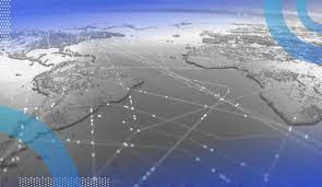
- Geospatial technology uses tools like GIS (Geographic Information System), GPS (Global Positioning System) and Remote Sensing for geographic mapping and analysis.
- These tools capture spatial information about objects, events and phenomena (indexed to their geographical location on earth, geotag). The location data may be Static or Dynamic.
- Static location data include position of a road, an earthquake event or malnutrition among children in a particular region while dynamic location data include data related to a moving vehicle or pedestrian, the spread of an infectious disease etc.
- The technology may be used to create intelligent maps to help identify spatial patterns in large volumes of data.
- The technology facilitates decision making based on the importance and priority of scarce resources.


