
LiDAR Market : Recent Research Report
According to a recent research report, LiDAR Market could thrive at a rate of 22.10% between 2022 and 2030.
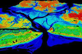
- LiDAR which stands for Light Detection and Ranging, is a remote sensing method that uses light in the form of a pulsed laser to measure ranges (variable distances) to the Earth.
- These light pulses—combined with other data recorded by the airborne system — generate precise, three-dimensional information about the shape of the Earth and its surface characteristics.
- There are three primary components of a LiDAR instrument — the scanner, laser and GPS receiver.
- Aeroplanes and helicopters are the most commonly used platforms for acquiring lidar data over broad areas.
- Two types of lidar are,
- Topographic lidar: It typically uses a near-infrared laser to map the land.
- Bathymetric lidar: It uses water-penetrating green light to also measure seafloor and riverbed elevations.
- A LiDAR system measures the time it takes for emitted light to travel to the ground and back.
- That time is used to calculate the distance travelled.
- Distance travelled is then converted to elevation.
- Lidar systems allow scientists and mapping professionals to examine both natural and manmade environments with accuracy, precision, and flexibility.
- It is used to produce more accurate shoreline maps, make digital elevation models for use in geographic information systems, assist in emergency response operations, and in many other applications.


