
Earthquake Struck Eastern Indonesia:
A 7.3-magnitude earthquake struck eastern Indonesia.
- The epicentre was in the Flores Sea, north of East Nusa Tenggara province.
- Indonesia sit along the Ring of Fire region, an area where most of the world’s volcanic eruptions occur.
- The Ring of Fire has seen a large amount of activity in recent days, but Indonesia has been hit hard due to its position on a large grid of tectonic plates.
- Indonesia is at the meeting point of three major continental plates – the Pacific, the Eurasian and the Indo-Australian plates – and the much smaller Philippine plate.
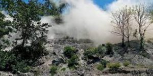
- As a result, several volcanoes on the Indonesian islands are prone to erupting. Indonesia is home to roughly 400 volcanoes, out of which 127 are currently active, accounting for about a third of the world’s active volcanoes.
- The Ring of Fire is a Pacific region home to over 450 volcanoes, including three of the world’s four most active volcanoes – Mount St. Helens in the USA, Mount Fuji in Japan and Mount Pinatubo in the Philippines. It is also sometimes called the circum-Pacific belt.
- Around 90% of the world’s earthquakes occur in the Ring of Fire, and 80% of the world’s largest earthquakes.
- It stretches along the Pacific Ocean coastlines, where the Pacific Plate grinds against other, smaller tectonic plates that form the Earth’s crust – such as the Philippine Sea plate and the Cocos and Nazca Plates that line the edge of the Pacific Ocean.
- The 40,000 kilometre horse-shoe-shaped ring loops from New Zealand to Chile, passing through the coasts of Asia and the Americas on the way.
- The Ring of Fire is the result from subduction of oceanic tectonic plates beneath lighter continental plates. The area where these tectonic plates meet is called a subduction zone.


